What WILL you make with a GPS enabled or very detailed track editor?

  • Thread starter smskeeter23
  • 1,100 comments
  • 105,358 views
2,006
United States
Port Washington
GTP_skeeter23
Like the title implies what would you map out. Or if we had enough control what would you try to make with the given tools?

There are three "sections" on my daily route that I have fun with everyday to and from work...

These would probably be the first I would make

picture.php


Which then contstructed into a track might end up something like this... (mapped sections highlighted)

picture.php


I think this would be pretty frickin cool. What say you?
What would you build?

Why not throw up a quick sketch or goolge map screenshot of a corner or corners you'd like to be able to drive in game ;)


How about this for a rally stage?
picture.php


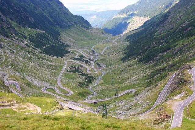
Or what about the road Top Gear named the greatest driving road in the world?
800x600_1271614492958.jpg
 
Last edited:
I like the GPS ideas and I have ideas for tracks but I would like to see what you can do with the track editor first before I make my mind up.
 
I would start by making a lap around the town I live in and if possible I would make the back side of the track gravel and the front side asphalt. There are lots and lots of roads nearby in this area that could be really cool to use. Which could be used would depend on the max length of the track.

I live in a valley with mountains on both sides so there are roads in the valley that have some fairly long straights and of course on the mountains there are some that would be very challenging with hairpin and switchback corners.
 
Hualapai Mountain Park which is northeast to where I live.

HualapaiMtnParkfull.JPG


Here is the road system inside the park itself.

hmpmap_new.jpg


This the roughly 11 mile Hualapai Mountain Road that takes you up to the park. Mountainous road with elevation changes and sharp corners a plenty. It also includes the "famous" Dead Man's Curve.

scenicMap_510.jpg


I am sure hoping for the GPS feature to allow me to do this.:)
 
Hualapai Mountain Park

Man I have got to try to get out there for some camping! Cool road structures always found in campgrounds and parks. Would be great for rally and hillclimb.

HBR-Roadhog
back side of the track gravel and the front side asphalt

That would be awesome if we could do split surface types!
 
Up go the hopes of a good track 'editor' (probably going to be a generator) again, only to be brought spectacularly back down to earth. But, if this ever did really get into the game I'd use the M25 as an endurance course.
 
Man I have got to try to get out there for some camping! Cool road structures always found in campgrounds and parks. Would be great for rally and hillclimb.

The hill-climb would be a treat, but I would love to see how fast I could go coming down HM Road.:lol:
 
I don't know how the GPS feature works? Is it a big map of the world and you make your track some where?? Can someone please explain to me?
 
Traviizter
Up go the hopes of a good track 'editor' (probably going to be a generator) again, only to be brought spectacularly back down to earth. But, if this ever did really get into the game I'd use the M25 as an endurance course.

Oh no I have no false assumptions here. I know it's VERY likely we will just get a generator but this is all in fun if "what would you do IF you could"...


mcalva98, there is no current GPS feature either in GT5 or announced for GT6.
 
smskeeter23
Oh no I have no false assumptions here. I know it's VERY likely we will just get a generator but this is all in fun if "what would you do IF you could"...

mcalva98, there is no current GPS feature either in GT5 or announced for GT6.

http://blog.us.playstation.com/2013/05/15/gran-turismo-6-unveiled-out-this-holiday-on-ps3/

This GT6 announcement article on the PlayStation blog states "Enhancements and improvements also extend to a much-improved course maker function, which will provide several kilometers of gorgeous scenery, including the magnificent backdrop of Andalucía. The course maker will also include a new GPS data feature, which will increase the freedom of track creation in the game." Yes, there technically is an announced GPS feature for GT6.
 
I sure hope your subdivision is better then the one I live in or work in!
haha Well it's that I don't have the nuggets anymore to drive fast around here at night. I'd rather keep it safe and not get a reckless driving charge. That being said, it does have some pretty fun twists and turns.
 
My location provides a clue, since a lot of the towns in SC Alaska could potentially have some pretty decent tracks mapped out around them. Wasilla and Palmer I've actually mapped out courses around, and I've seen plenty of ideas for Anchorage.
 
Lotus380
The course maker will also include a new GPS data feature, which will increase the freedom of track creation in the game." Yes, there technically is an announced GPS feature for GT6.

How has this NOT been shouted everywhere repeatedly here on GTP? Every mention I've seen is always shot down as inaccurate.

Perhaps this thread just got real? Wow.

@white and nerdy... I used to have a 4cyl Turbo j-body ;-) What you "need" is a Turbo V6 G body :sly:
 
You mean this?:

transfagarasan.jpg~original

Nothing to complain about there, but it's a little like just racing from hairpin to hairpin. I think I'd prefer the flow of the Targa Florio, but a combination of the two would be great!!

Can we get someone who live there to map that road so it can be exported to GT6 Andalucia map ? I hope no one asking for a fortune to share this kind of hard to get track made from GPS data.
 
haha Well it's that I don't have the nuggets anymore to drive fast around here at night. I'd rather keep it safe and not get a reckless driving charge. That being said, it does have some pretty fun twists and turns.

That's quite the departure from where I live. I built my house in a subdivision that is square as square gets.

The one that our office is based in is barely any better!
 
Can we get someone who live there to map that road so it can be exported to GT6 Andalucia map ? I hope no one asking for a fortune to share this kind of hard to get track made from GPS data.

If the GPS feature works the way we hope it does, I'm sure there will be a thriving market for tracks like this. If it was possible to use the elevation and GPS tracking data from Google Earth...that would open up a whole slew of possibilities. :)
 
If the GPS feature works the way we hope it does, I'm sure there will be a thriving market for tracks like this. If it was possible to use the elevation and GPS tracking data from Google Earth...that would open up a whole slew of possibilities. :)

Just hoping we can share more than one track at a time, or better yet send the track like we send cars/paint.
 
How has this NOT been shouted everywhere repeatedly here on GTP? Every mention I've seen is always shot down as inaccurate.

Perhaps this thread just got real? Wow.

@white and nerdy... I used to have a 4cyl Turbo j-body ;-) What you "need" is a Turbo V6 G body :sly:

Grand National right? Wouldn't mind having one of those myself. Only problem is a mandatory automatic transmission, which could be troublesome on roads like, say, this.
 
I'd make up a few roads around where I live, some pretty decent ones. Might even put pot holes in the roads just to spice it up! :dopey:

And I'd also make up tracks that haven't been included in the game, most likely places like Donington, Zandvoort, Imola etc.
 
Portions of LA. Has anyone seen IRT: Deadliest Roads? Yungas Road simply for time attack with all the hazards of course. It will be a great finale for a rally series. Lol
 
Only if GPS works I would make a grand gift to the community!

2 roads where I live which are amazing!

1st: https://maps.google.com/maps?saddr=%CE%99%CF%8C%CE%BD%CE%B9%CE%B1+%CE%9F%CE%B4%CF%8C%CF%82%2FE55%2FE65&daddr=%CE%A6%CF%81%CE%B5%CE%B9%CE%B4%CE%B5%CF%81%CE%AF%CE%BA%CE%B7%CF%82&hl=el&ie=UTF8&ll=38.345964,22.206116&spn=0.825012,1.234589&sll=38.476287,22.497146&sspn=0.012868,0.01929&geocode=FfT4SAIdZBhMAQ%3BFZIgSwIdf0hXAQ&t=h&mra=mift&mrsp=1&sz=16&z=10

This one you start from the Bridge across the bay and there is a long way on the base of mountains which start from the sea! In the end of the route you being to climb the mountain with numerous hairpins (some of them very fast) and finish your destination at the oracle of Delphi! I used to do this route on my bike with friends. Amazing scenery and great turns with good quality asphalt!

2.) https://maps.google.com/maps?saddr=%CE%86%CE%B3%CE%BD%CF%89%CF%83%CF%84%CE%BF%CF%82+%CE%B4%CF%81%CF%8C%CE%BC%CE%BF%CF%82&daddr=38.2941565,21.8391805+to:%CE%86%CE%B3%CE%BD%CF%89%CF%83%CF%84%CE%BF%CF%82+%CE%B4%CF%81%CF%8C%CE%BC%CE%BF%CF%82&hl=el&ie=UTF8&sll=38.256515,21.912918&sspn=0.206508,0.308647&geocode=FSyTSAIdruhMAQ%3BFYxSSAIdTD1NASm3QN6zW0teEzHmQ_ty_XCWQw%3BFTlfSAIdP7ZPAQ&t=h&dirflg=ht&mra=dpe&mrsp=1&sz=12&via=1&z=12

This is the route I take to go to my grandparents. Steep mountain going up and down full of hairpins but with some very fast spots! Beautiful view and good quality asphalt. They make an "ascend/descend" type of race every year. One year they even had formula 3 :).

If GT6 has a way to make it with the GPS, I would gladly grab the bike and get some data on the GPS to upload for the track! I promise to my GTP honor :)
 
Back