You are using an out of date browser. It may not display this or other websites correctly.
You should upgrade or use an alternative browser.
You should upgrade or use an alternative browser.
Oddities of geography
- Thread starter GranTurNismo
- 97 comments
- 12,973 views
- 9,262

- Corsham
- lipming
Edinburgh, on the east cost of Great Britain, is further west than Bristol on the west coast.
Anna Creek Station, a cattle ranch in South Australia with only eight full-time employees, is larger than Israel.
The Goldfields-Esperance region of Western Australia, a subdivision within a subdivision, would be the world's 36th largest nation if it declared independence; and with a population of 60,000, almost half of which live just in Kalgoorlie, would also have the lowest population density of any nation at 0.09 people per square kilometre, beaten by Mongolia by a factor of 20, and only beaten overall by Svalbard & Jan Mayen and Greenland.
- 19,425

- HSV
Horrific
Looks worse than it is, but still drives slower than the speed limit.
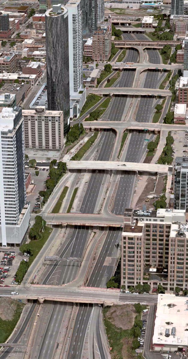
This was the consequence of early freeway design, before federal design standards and when freeways / expressways were usually just for connecting one part of a city with another, before any sort of connection with other freeways existed. So many city streets were given access ramps, thinking it would reduce overall traffic, but it just creates major congestion, after all, they weren't designed for travel spanning long distances.
In this example, the Dan Ryan was given additional Express Lanes for those that weren't going to weave on and off the Interstate for just a short distance, but head to more major destinations (for example, where this one splits off into the Chicago Skyway, and heads to the Indiana Toll Road).
The typical rule of thumb for modern limited-access roads in the US is to use no more than than one exit per mile of freeway, except if it has separate east-west or north-south exits. In this stretch, there's nine exits for that mile in downtown Chicago.
Last edited:
- 19,425
- HSV
It would probably then create gridlock on the surface streets because then there would be backups to get onto the desired highway. You could lengthen the ramp by using the closed-off exits, which does occur sometimes when rehabbing an old freeway corridor.Why don't they close a bunch of them and just leave the northern and southmost ones?
In the end, lowest bidding works project wins out and that's how it goes.
Last edited:
- 5,358
- Ohio
Turn here?
No.
Here?
Wait.
This one?
No.
Here?
I said wait!
Here?
Wrong lane!
Not here?
Here! Go! Missed it.
You said wrong lane…
Legit scene there.
No.
Here?
Wait.
This one?
No.
Here?
I said wait!
Here?
Wrong lane!
Not here?
Here! Go! Missed it.
You said wrong lane…
Legit scene there.
- 16,429
- United Kingdom
At 0°N 0°E there is a place called Null Island, but it's not an island, or really a place, it's just a buoy taking climate readings.
edit: Also, frustratingly, it's never the answer on GeoGuessr.
edit: Also, frustratingly, it's never the answer on GeoGuessr.
Last edited:
- 28,528

- Bratvegas
- GTP_Liquid


- 3,713

- Null Island
Man the graphics for Cities:Skylines II are amazingSNIP

- 16,429
- United Kingdom
Got bad traffic at a junction, build another junction!Man the graphics for Cities:Skylines II are amazing
... and so on ... and so on ... and so on ...
- 28,528
- Bratvegas
- GTP_Liquid
Just add more lanes. One more should do it!Got bad traffic at a junction, build another junction!
... and so on ... and so on ... and so on ...
- 15,094

- Melbourne
- ScottPuss20
- CheetahsMeow
What a mess.
- 3,656
- Elizabeth, New Jersey, USA
I find it funny that you can literally travel south from Arkansas… into Missouri. Which is a Midwestern state. Thanks to the bootheel.It's possible to travel south from Arkansas into every single one of the seven other States that surround it, despite it being in south-central USA.
- 19,425
- HSV
Arkansas borders six states: Missouri, Tennessee, Mississippi, Louisiana, Texas, andIt's possible to travel south from Arkansas into every single one of the seven other States that surround it, despite it being in south-central USA.
Oklahoma. It does get close to Kentucky to its northeastern side and Kansas to its northwest, but they do not share a legally-defined border.
Curiously, New York and Rhode Island share a maritime border, as do Michigan and Illinois. I believe those are the only water-only borders in the contiguous continental US.
Last edited:
- 5,014
- Panama City, FL
Delaware and New Jersey don't touch by land, but are across the Delaware River and Delaware Bay from each other. Counting the river probably isn't "maritime," even if it is only a short stretch and fairly wide there. (Otherwise there would be numerous state pairs separate by water.)
- 19,956
- NJ/USA
- Blitzbay
- Blitzbay
This is false. Although it is not well known, there are two portions of Delaware that are on the eastern bank of the Delaware River and thus share a land border with New Jersey.Delaware and New Jersey don't touch by land, but are across the Delaware River and Delaware Bay from each other. Counting the river probably isn't "maritime," even if it is only a short stretch and fairly wide there. (Otherwise there would be numerous state pairs separate by water.)
- 19,425
- HSV
This is false. Although it is not well known, there are two portions of Delaware that are on the eastern bank of the Delaware River and thus share a land border with New Jersey.
A little piece of Delaware is actually hidden in N.J. How did that happen?
Many people do not know that New Jersey shares land borders with Delaware


- 15,094
- Melbourne
- ScottPuss20
- CheetahsMeow
I don't know if this is weird or not but Rottnest Island has several lakes inside it.
.png")
.png")
Last edited:
- 34,809
- NoDak
- Cy-Fi
An island inside of a lake inside of an island:I don't know if this is weird or not but Rottnest Island has several lakes inside it.
View attachment 1299255
View attachment 1299256
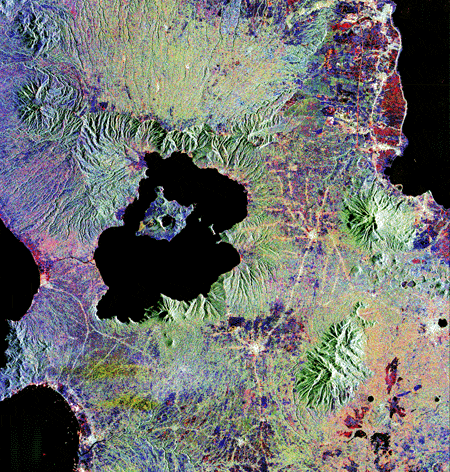
Taal Lake - Wikipedia
- 243
- Yorkshire, Gods Own County
- AEKara38
I've been to Taal and there's an island inside the lake inside the island inside the lake (inside the island if you class Luzon as an island).
Latest Posts
-
-
-

-
Introduce Yourself! New Member Introductions Thread — Come Say Hello!
- Latest: forthemany217