Keef
Premium
- 24,550

- Dayton, OH
- GTP_KeefRacer
- GTP Keef
I've only found passing mentions of geography and interesting maps on GTP so figured I would give this discussion a new home, and hopefully we can dig into it with a little more detail. I've had a passing interest in maps since I was a kid and while I'm not sure my thousands of hours of Sim City is related to my career in aviation, my interest really take off when I took a couple landscape architecture electives at university. I learned so much fascinating history - much of which I forget - about humanity's various quests to be one with nature, or to redesign nature, or to create order, or eschewing order altogether. From silly Brits and their metes and bounds, to the American Public Land Survey System, to the French Colonial seigneurial long lots, to strict Spanish Colonial grids and urban parks, they all exist here in the US and simultaneously were the result of different cultural influences and created their own cultural differences over time. These classes forced me to rethink how I saw society now and how historical decisions effected it, and was a reason for my huge changes in political philosophy.
Other very interesting topics are directly related to the many social issues we're discussing right now, such as red lining, segregation, the interstate highway system, the concepts of neighborhoods and suburbs, and how these things and others effect the health of cities, entire societies, and influence politics. Did you know Buffalo, New York used to have the premier urban park and parkway system in the world outside of Europe before it was demolished in favor of asphalt? Did you know Central Park is almost entirely man-made, even down to where the trees were planted, but you couldn't really tell until they decided to pave a race track through it in the 1930s? Did you know that freeways in America weren't just designed to be efficient, but were also designed to segregate cities, and there is a broad movement to redesign them or even demolish some to repair the damage done? The depth of influence over society that urban planning has is fascinating and it has been wielded to both create and destroy. Lately I've been browsing the differences between American and Canadian cities and I'm stunned by all the differences, some good and some bad, but overall the seemingly huge urban health advantage that Canada has over the US despite a seemingly identical culture of expansion and exploration, and I'm really curious what choices have led to our differences and whether or not one method was better than the other.
____________
Anyways, I'll start with a couple examples from places I've lived, in Dayton andColumbus Flavortown, Ohio. The first is something I just learned about a few days ago but got me very excited, especially given Dayton's history and current reality throughout my lifetime. Dayton has a glorious history of invention and wealth with people and companies like James Ritty, John Patterson, NCR, the Wright Brothers, Charles F. Kettering, Delco, the Manhattan Project, and others. But after Dayton's industrial peak in the 1960s the city fell off rapidly, especially during the1970s (incidentally when my parents also contributed to white flight, leaving Dayton for new suburbs to the south). Another aside is that the suburb I grew up in happened to the the end of the south-to-north line of I-75 while construction struggled through downtown Dayton, resulting in a ridiculously poorly designed interchange that lasted until 2014 or so.
These highways were intended to facilitate movement but instead contributed massively to urban decay in Dayton, and did so around the country. In favor of urban health we designed for suburban expansion. One notably destructive highway in Dayton is part of US-35, and is an elevated highway barreled through pre- and post-war neighborhoods and entangled by outrageous interchanges and ramps for good measure. You gotta see this:

What in tarnation? But I learned that as far back as 2013 a new idea was floated to get rid of it. Tear it all down. Reconnect surface roads, redevelop neighborhoods, add necessary services, shops, groceries, and revitalize an area that has been suffering for 50+ years now. What a fantastic idea!
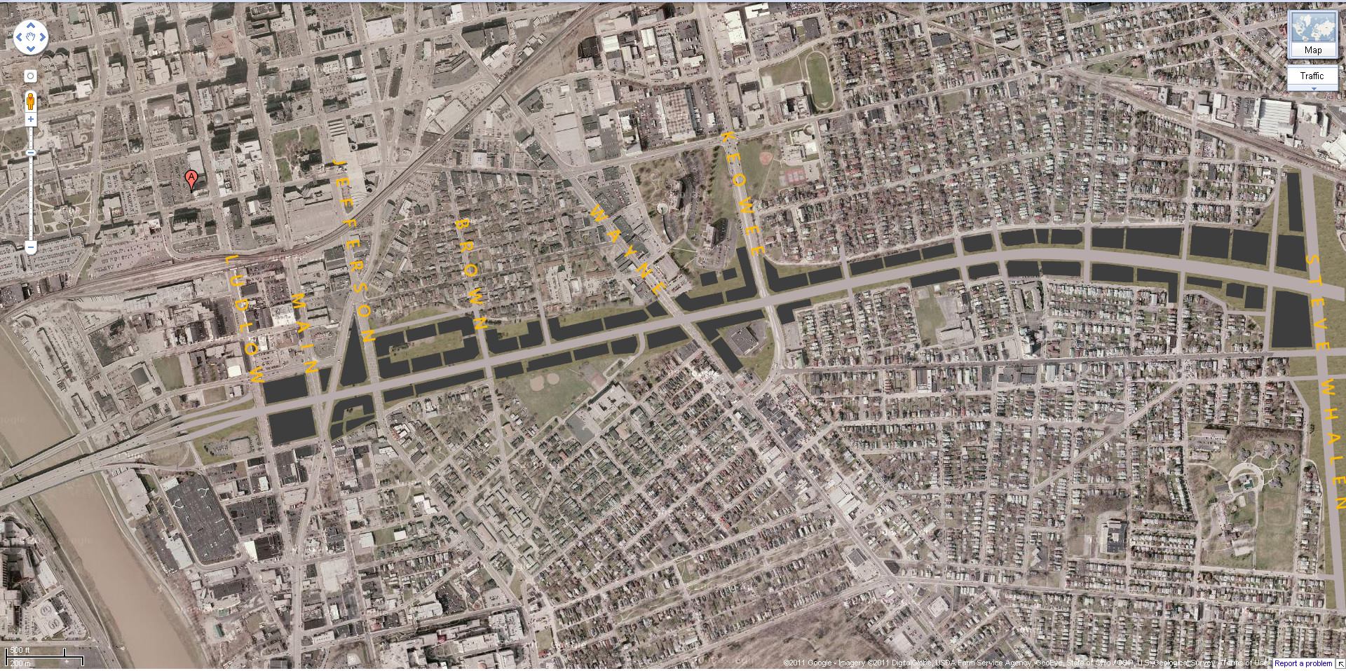
A similar (and more colorful) idea had been floated back in 2011:
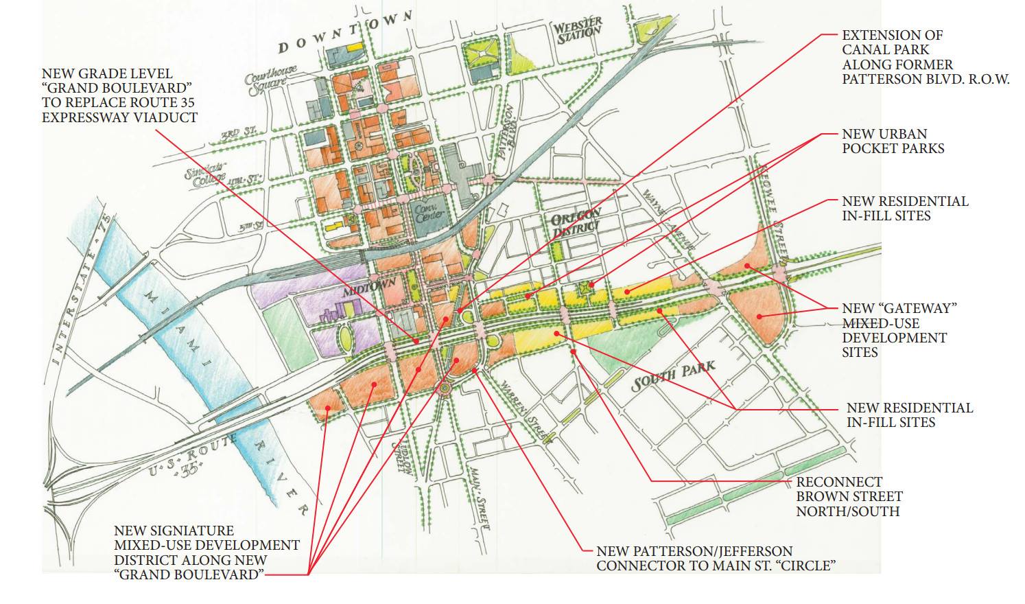
If you're familiar with the area and have any sort of design imagination, it's easy to see how getting rid of this highway in favor of a redeveloped boulevard actually makes a lot of sense. Any of you guys studying a map of Dayton can probably identify several alternative roads serving as east-west corridors in the same region of the city and how they could be more effective if improved further. My local knowledge suggests that much of the traffic in this area is not caused by roads being overloaded, but by people trying to concentrate themselves onto 35 because they all believe it to be quicker. I can tell you from experience, when that backup occurs it's not longer quicker, yet for decades people have persisted, attempting to drive as quickly through these neighborhoods as possible because none of them are very pretty. Total disregard for the actual people who live in these neighborhoods and their needs which are certainly not served by having an elevated freeway in their back yard. If you choose to live 20+ minutes from the central business district of a medium-sized city then you should not reserve the right to drive straight through people's yards to save a couple minutes.
Here's an entire article covering the basics of several similar highways that may be completely removed in the future. And off the top of my head I can think of a couple other recent examples, including Milwaukee and this Akron branch.
What do you think about this? Are there any examples of road or highway planning, or lack thereof, that you think needs to be changed in your city? Perhaps something that has proven more destructive than helpful, especially when it comes to social demographics and/or economics? What mistakes do you think have been made and are there plans to fix them? And what about in Europe, have y'all been effected by this blatant destruction or were cars never designated as the primary mode of transportation? Did your vast metro systems cause damage to neighborhoods (Chicago's elevated trains would make spectacular neighbors)?
Other very interesting topics are directly related to the many social issues we're discussing right now, such as red lining, segregation, the interstate highway system, the concepts of neighborhoods and suburbs, and how these things and others effect the health of cities, entire societies, and influence politics. Did you know Buffalo, New York used to have the premier urban park and parkway system in the world outside of Europe before it was demolished in favor of asphalt? Did you know Central Park is almost entirely man-made, even down to where the trees were planted, but you couldn't really tell until they decided to pave a race track through it in the 1930s? Did you know that freeways in America weren't just designed to be efficient, but were also designed to segregate cities, and there is a broad movement to redesign them or even demolish some to repair the damage done? The depth of influence over society that urban planning has is fascinating and it has been wielded to both create and destroy. Lately I've been browsing the differences between American and Canadian cities and I'm stunned by all the differences, some good and some bad, but overall the seemingly huge urban health advantage that Canada has over the US despite a seemingly identical culture of expansion and exploration, and I'm really curious what choices have led to our differences and whether or not one method was better than the other.
____________
Anyways, I'll start with a couple examples from places I've lived, in Dayton and
These highways were intended to facilitate movement but instead contributed massively to urban decay in Dayton, and did so around the country. In favor of urban health we designed for suburban expansion. One notably destructive highway in Dayton is part of US-35, and is an elevated highway barreled through pre- and post-war neighborhoods and entangled by outrageous interchanges and ramps for good measure. You gotta see this:
What in tarnation? But I learned that as far back as 2013 a new idea was floated to get rid of it. Tear it all down. Reconnect surface roads, redevelop neighborhoods, add necessary services, shops, groceries, and revitalize an area that has been suffering for 50+ years now. What a fantastic idea!

A similar (and more colorful) idea had been floated back in 2011:

If you're familiar with the area and have any sort of design imagination, it's easy to see how getting rid of this highway in favor of a redeveloped boulevard actually makes a lot of sense. Any of you guys studying a map of Dayton can probably identify several alternative roads serving as east-west corridors in the same region of the city and how they could be more effective if improved further. My local knowledge suggests that much of the traffic in this area is not caused by roads being overloaded, but by people trying to concentrate themselves onto 35 because they all believe it to be quicker. I can tell you from experience, when that backup occurs it's not longer quicker, yet for decades people have persisted, attempting to drive as quickly through these neighborhoods as possible because none of them are very pretty. Total disregard for the actual people who live in these neighborhoods and their needs which are certainly not served by having an elevated freeway in their back yard. If you choose to live 20+ minutes from the central business district of a medium-sized city then you should not reserve the right to drive straight through people's yards to save a couple minutes.
Here's an entire article covering the basics of several similar highways that may be completely removed in the future. And off the top of my head I can think of a couple other recent examples, including Milwaukee and this Akron branch.
What do you think about this? Are there any examples of road or highway planning, or lack thereof, that you think needs to be changed in your city? Perhaps something that has proven more destructive than helpful, especially when it comes to social demographics and/or economics? What mistakes do you think have been made and are there plans to fix them? And what about in Europe, have y'all been effected by this blatant destruction or were cars never designated as the primary mode of transportation? Did your vast metro systems cause damage to neighborhoods (Chicago's elevated trains would make spectacular neighbors)?
Last edited:

