The Urban Planning and Geography Thread

  • Thread starter Keef
  • 8 comments
  • 698 views

Keef

Premium
24,508
United States
Dayton, OH
GTP_KeefRacer
GTP Keef
I've only found passing mentions of geography and interesting maps on GTP so figured I would give this discussion a new home, and hopefully we can dig into it with a little more detail. I've had a passing interest in maps since I was a kid and while I'm not sure my thousands of hours of Sim City is related to my career in aviation, my interest really take off when I took a couple landscape architecture electives at university. I learned so much fascinating history - much of which I forget - about humanity's various quests to be one with nature, or to redesign nature, or to create order, or eschewing order altogether. From silly Brits and their metes and bounds, to the American Public Land Survey System, to the French Colonial seigneurial long lots, to strict Spanish Colonial grids and urban parks, they all exist here in the US and simultaneously were the result of different cultural influences and created their own cultural differences over time. These classes forced me to rethink how I saw society now and how historical decisions effected it, and was a reason for my huge changes in political philosophy.

Other very interesting topics are directly related to the many social issues we're discussing right now, such as red lining, segregation, the interstate highway system, the concepts of neighborhoods and suburbs, and how these things and others effect the health of cities, entire societies, and influence politics. Did you know Buffalo, New York used to have the premier urban park and parkway system in the world outside of Europe before it was demolished in favor of asphalt? Did you know Central Park is almost entirely man-made, even down to where the trees were planted, but you couldn't really tell until they decided to pave a race track through it in the 1930s? Did you know that freeways in America weren't just designed to be efficient, but were also designed to segregate cities, and there is a broad movement to redesign them or even demolish some to repair the damage done? The depth of influence over society that urban planning has is fascinating and it has been wielded to both create and destroy. Lately I've been browsing the differences between American and Canadian cities and I'm stunned by all the differences, some good and some bad, but overall the seemingly huge urban health advantage that Canada has over the US despite a seemingly identical culture of expansion and exploration, and I'm really curious what choices have led to our differences and whether or not one method was better than the other.

____________

Anyways, I'll start with a couple examples from places I've lived, in Dayton and Columbus Flavortown, Ohio. The first is something I just learned about a few days ago but got me very excited, especially given Dayton's history and current reality throughout my lifetime. Dayton has a glorious history of invention and wealth with people and companies like James Ritty, John Patterson, NCR, the Wright Brothers, Charles F. Kettering, Delco, the Manhattan Project, and others. But after Dayton's industrial peak in the 1960s the city fell off rapidly, especially during the1970s (incidentally when my parents also contributed to white flight, leaving Dayton for new suburbs to the south). Another aside is that the suburb I grew up in happened to the the end of the south-to-north line of I-75 while construction struggled through downtown Dayton, resulting in a ridiculously poorly designed interchange that lasted until 2014 or so.

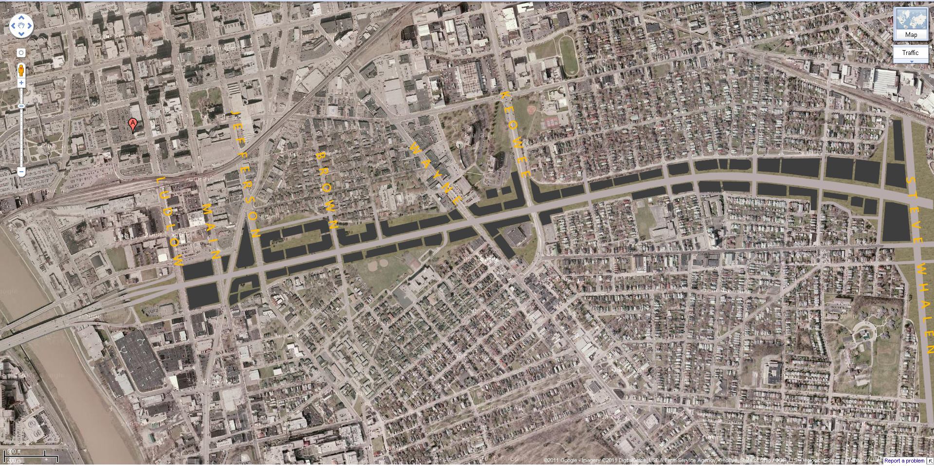
These highways were intended to facilitate movement but instead contributed massively to urban decay in Dayton, and did so around the country. In favor of urban health we designed for suburban expansion. One notably destructive highway in Dayton is part of US-35, and is an elevated highway barreled through pre- and post-war neighborhoods and entangled by outrageous interchanges and ramps for good measure. You gotta see this:

Capture-US-35-Dayton.JPG


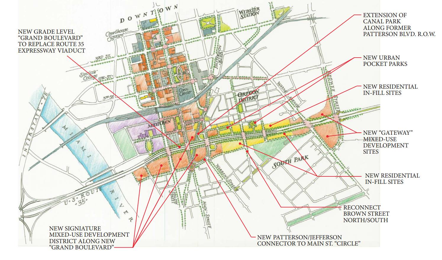
What in tarnation? But I learned that as far back as 2013 a new idea was floated to get rid of it. Tear it all down. Reconnect surface roads, redevelop neighborhoods, add necessary services, shops, groceries, and revitalize an area that has been suffering for 50+ years now. What a fantastic idea!


A similar (and more colorful) idea had been floated back in 2011:


If you're familiar with the area and have any sort of design imagination, it's easy to see how getting rid of this highway in favor of a redeveloped boulevard actually makes a lot of sense. Any of you guys studying a map of Dayton can probably identify several alternative roads serving as east-west corridors in the same region of the city and how they could be more effective if improved further. My local knowledge suggests that much of the traffic in this area is not caused by roads being overloaded, but by people trying to concentrate themselves onto 35 because they all believe it to be quicker. I can tell you from experience, when that backup occurs it's not longer quicker, yet for decades people have persisted, attempting to drive as quickly through these neighborhoods as possible because none of them are very pretty. Total disregard for the actual people who live in these neighborhoods and their needs which are certainly not served by having an elevated freeway in their back yard. If you choose to live 20+ minutes from the central business district of a medium-sized city then you should not reserve the right to drive straight through people's yards to save a couple minutes.

Here's an entire article covering the basics of several similar highways that may be completely removed in the future. And off the top of my head I can think of a couple other recent examples, including Milwaukee and this Akron branch.

What do you think about this? Are there any examples of road or highway planning, or lack thereof, that you think needs to be changed in your city? Perhaps something that has proven more destructive than helpful, especially when it comes to social demographics and/or economics? What mistakes do you think have been made and are there plans to fix them? And what about in Europe, have y'all been effected by this blatant destruction or were cars never designated as the primary mode of transportation? Did your vast metro systems cause damage to neighborhoods (Chicago's elevated trains would make spectacular neighbors)?
 
Last edited:
It's interesting to study the satellite pictures of Dayton. The city is about twice the size as my hometown (Umeå, Sweden) in terms of population, but in terms of area it seems to be around 4 times larger.

dayton.png
umea.png


You can also see huge differences in the road network, with Dayton having significantly more large roads. In Umeå you can only see a handful of roads drawn out on the map.

Comparing satellite images, Dayton appears to be dominated by single-family homes. An interesting thing to note is also that these houses are packed really close together, but at the same time there is a lot of empty space.

dayton_housing.PNG


A similar area in Umeå would be something like this one below, with single-family homes. Note that there are gaps between the houses of around 8-10 meters (I believe fire regulations mandate a minimum distance of 8 meters). There is also no empty space, apart from one or two parks.
umeå_housing.PNG


Umeå also have other types of residential areas, like these three below that are dominated by multi-family houses. I saw a couple of apartment buildings in Dayton but I didn't spot any neighbourhoods similar to these.
umeå_housing_2.PNG umeå_housing_3.PNG umeå_housing_4.PNG

Another really interesting thing to note is the amount of parking space in Dayton, some areas are completely dominated by parking lots:
dayton_parking.PNG


Based on the satellite photos it seems to me like the single-family houses in combination with a lot of unused land leads to a city with a big geographical footprint, which leads to a dependency on cars, which leads to a high demand for parking lots, which leads to an even larger geographical footprint. Plus a whole lot of traffic issues, I imagine.
 
...leads to a city with a big geographical footprint, which leads to a dependency on cars, which leads to a high demand for parking lots, which leads to an even larger geographical footprint...

From the American point of view, you've actually got that cause and effect backwards. We don't depend on cars because everything is so spread out, but rather everything is so spread out because we love our cars. Public transportation, except in ultra-dense urban areas like Manhattan (where the subway and cabs are preferred,) are not widely used by folks who can afford the cars and the parking. The feeling is, the car gives independence; you're not tied to the train schedule or bus schedule, or the locations of stops. If can run a car, you don't give that up. Roads and parking are done to accommodate that.

Not to mention, for the most part, we do have the room!

As to the redevelopment of that US 35 corridor, I worry. Surface roads do NOT work like expressways, even overloaded expressways. If folks don't want to use that route, where are they going to go? Is there a useful alternate that can handle the traffic? Surface roads require traffic control, like one-way streets and traffic lights, and these control traffic by making everyone stop and wait. This is more efficient??? Unless that redevelopment actually makes that a destination, removing the expressway without replacing it with an alternate freeway route is asking for trouble.

By destination, what I mean is that most of that traffic on that expressway has no interest in the immediate area; they are going from somewhere off the map to on one end to somewhere off the map on the other end. Encumbering them with surface roads is... dumb.

As an example, the local airport currently has its access road intersecting the county highway at a T-junction with a simple stop sign, not even a traffic light. The airport board or the road department, or both together, designed a two-lane roundabout for easier access on and off of the airport access road. The problem with that is a basic assumption that most, or even half, of the traffic out there was headed for the airport, which simply isn't true. You're going to take 100% of the 60-MPH traffic and slow them down to 35 so they can pass through the roundabout on their way to wherever, so <10% of the traffic can turn off or merge. Dumb, dumb, dumb. granted, the roundabout is better than a simple T, but it forces ALL traffic to participate in the junction, whether destined for the airport or not. An overpass with ramps would have allowed through traffic, which is by a large margin most of the traffic, to pass unimpeded, yet allowing airport traffic easier access than they currently have. I can only assume the cost of the overpass would be significantly higher.
 
Last edited:
Oh man, I'm all about this thread. Definitely gonna get in the weeds here later. I took some planning classes in grad school and I even took a course specifically about suburbia. It is a pretty damn fascinating history. I'd recommend The Death and Life of Great American Cities by Jane Jacobs on the subject.

Somewhat related, this is a pretty awesome film about Pruitt Igoe in Saint Luis and the failures of American social housing. It's long, but it's great. Trailer below.

 
Last edited:
It's interesting to study the satellite pictures of Dayton. The city is about twice the size as my hometown (Umeå, Sweden) in terms of population, but in terms of area it seems to be around 4 times larger.

View attachment 978293 View attachment 978294

You can also see huge differences in the road network, with Dayton having significantly more large roads. In Umeå you can only see a handful of roads drawn out on the map.

Comparing satellite images, Dayton appears to be dominated by single-family homes. An interesting thing to note is also that these houses are packed really close together, but at the same time there is a lot of empty space.

View attachment 978296

A similar area in Umeå would be something like this one below, with single-family homes. Note that there are gaps between the houses of around 8-10 meters (I believe fire regulations mandate a minimum distance of 8 meters). There is also no empty space, apart from one or two parks.
View attachment 978297

Umeå also have other types of residential areas, like these three below that are dominated by multi-family houses. I saw a couple of apartment buildings in Dayton but I didn't spot any neighbourhoods similar to these.
View attachment 978298 View attachment 978299 View attachment 978302

Another really interesting thing to note is the amount of parking space in Dayton, some areas are completely dominated by parking lots:
View attachment 978303

Based on the satellite photos it seems to me like the single-family houses in combination with a lot of unused land leads to a city with a big geographical footprint, which leads to a dependency on cars, which leads to a high demand for parking lots, which leads to an even larger geographical footprint. Plus a whole lot of traffic issues, I imagine.
Nice! You've absolutely highlighted a couple of America's problems, the first of which is the almost universal dominance of cars, and the other is the regional problem of industrial decline combined with white flight. There are several layers to these issues and they all overlap.

As for Dayton's modern density problem, it wasn't always like that. All those empty lots between houses you highlighted used to be more houses. Here's that same neighborhood of Hoover Ave and Brooklyn Ave that you screenshotted from 1956:

Capture-Dayton-1956.JPG


Very few empty lots. These houses are actually quite similar to the ones you highlight in Sweden, with detached garages in the back yards. These houses are densely packed single-family homes as is the American way but this neighborhood is also literally a five minute drive from downtown. Back in the pre- and post-war industrial boom, this was a great place to raise a family. Today, it's one of the most downtrodden neighborhoods in the city. In fact, my admittedly racist parents left this neighborhood specifically in 1977 and moved to a brand new suburb south of town where I grew up.

Just to the east of your screenshot I can show you can example of the industrial decline which also contributed to falling urban population. You may not have noticed this field when you were browsing, but if I expand your screenshot just a little...

Capture-Dayton-Tire-Company-2020.JPG


Capture-Dayton-Tire-Company-1956.JPG


Oh my. There used to be a fairly large factory there, probably employing a couple hundred people, some of whom may have walked to work. The historical imagery (I don't think they allow direct linking) and some digging says the factory was owned by Firestone and closed in 1980 along with several others from several companies, and thousands of jobs. If you drove past the factory grounds today you would think you were in the country on the outskirts of the city, that's how empty it is, but no, you're right smack in the middle of what was a dense urban neighborhood. For nearly 40 years that land has sat empty with no market demand for new development. As a small-medium post-industrial American city, Dayton's urban revitalization plans were much slower to get going than bigger cities and is still in its infancy today.

Another note from these screenshots, you can see yet another remnant of America's out-of-control car culture in that road named James H. McGee Boulevard. I'm looking at it, and looking at the dead factory (which in all fairness was still operating when they built that road), and looking at my own experience driving on James H McGee, and I'm thinking, "Why?". It's not busy, it's never busy. They tore down dozens of houses to build a road designed for westward expansion of the city, but the city never expanded westward.

Capture-James-H-Mcgee-2020.JPG


Instead of expanding, this entire west side of the city (west siiiiiide) basically died from the 70s onward. Despite all of James H McGee Blvd's efforts to facilitate travel from one place over hear to another place literally a mile away, the neighborhood died. In fact, in the southeast corner of this shot, just west of the river, you can see the huge lack of density, all of which became large abandoned in the late 20th century despite proximity to downtown just across the river. Actually, that main road shooting westward across the river from downtown is in the first stages of a revitalization, with a new neighborhood built, some new restaurants and shops, etc. The rest of this region is experiencing some mild real estate redevelopment but it's very early. I wouldn't doubt Dayton finally does expand westward (and maybe finally reach the failed "loop" of 49 on the western edge of this shot, and yes 35 continues to barrel along the southern portion out of view, ultimately turning north and becoming 49) but it'll probably take...40 years. Then again, they've got a helluva lot of empty lots to fill before they need to expand.

Speaking of urban neighborhood renewal, here's an example of what a much larger city and metro area can accomplish:

Capture-Cleveland-redevelopment-2020.JPG


Capture-Cleveland-redevelopment-2-2020.JPG


That's in Cleveland. The Street View slider shows this area was under construction back in 2007. Since then, Cleveland has been one of the American cities with a policy of demolishing old structures on purpose and gathering investment to build new and revitalize old neighborhoods. Cleveland was hit hard by industrial decline and some of its inner city neighborhoods were almost completely abandoned.

Man, there's so much stuff to analyze even about my one little city lol. US-35 and plans to redesign it, its original failed designs and unforeseen industrial decline killing the projects, etc. I haven't gone over the annoyances of Columbus yet either. Also I want to make a point related to your question of density when it comes to the US and Canada. In some places our two countries have cities right next to each other but which clearly have different urban planning philosophies.

Edit: @eran0004 For reference to these City of Dayton areas we're discussing, and because I usually consider "Dayton" as the entire metro area, not just the city proper, this is a southern suburb of Dayton called Kettering, named after Charles F. Kettering. Very similar to where I grew up, middle class, mostly single-family houses but also scattered apartment buildings and complexes. Shopping centers built in the 60s and 70s, ugh. But it's peaceful and basically requires driving cars. An interesting note is that from this screenshot there are four effective ways to reach downtown Dayton, all of which take the exact same amount of time. I used to live here, I tested them all lol. The two surface streets in this shot, Far Hills (48) and Wilmington Pike both are pointing right at downtown to the north, but there are also two freeway routes, one involving US-35, which are higher speed but have to be reached by a couple east-west surface streets. You can probably guess that most people are in the habit of taking the longer distance but higher speed route because "the freeway is faster" @wfooshee This is part of what I want to highlight for you later.

Capture-kettering-2020.JPG


Capture-kettering-2-2020.JPG


@wfooshee I'll have to whip out the photoshop later to address your points but yes I believe there are plenty of alternative routes which both are underutilized and were never properly modernized specifically because that stretch of 35 existed. I'll highlight some local and cross-town aspects of this soon.

I'd recommend The Death and Life of Great American Cities by Jane Jacobs on the subject.
A couple books I read for class included The Machine in the Garden by Leo Marx and Nature's Metropolis: Chicago and the Great West by William Cronon. Both are great reads but were written in 2000 1967 and 1992 respectively so quite old already. The science on the subject is evolving faster than ever these days.
 
Last edited:
It's interesting to study the satellite pictures of Dayton. The city is about twice the size as my hometown (Umeå, Sweden) in terms of population, but in terms of area it seems to be around 4 times larger.

View attachment 978293 View attachment 978294

You can also see huge differences in the road network, with Dayton having significantly more large roads. In Umeå you can only see a handful of roads drawn out on the map.

Comparing satellite images, Dayton appears to be dominated by single-family homes. An interesting thing to note is also that these houses are packed really close together, but at the same time there is a lot of empty space.

View attachment 978296

A similar area in Umeå would be something like this one below, with single-family homes. Note that there are gaps between the houses of around 8-10 meters (I believe fire regulations mandate a minimum distance of 8 meters). There is also no empty space, apart from one or two parks.
View attachment 978297

Umeå also have other types of residential areas, like these three below that are dominated by multi-family houses. I saw a couple of apartment buildings in Dayton but I didn't spot any neighbourhoods similar to these.
View attachment 978298 View attachment 978299 View attachment 978302

Another really interesting thing to note is the amount of parking space in Dayton, some areas are completely dominated by parking lots:
View attachment 978303

Based on the satellite photos it seems to me like the single-family houses in combination with a lot of unused land leads to a city with a big geographical footprint, which leads to a dependency on cars, which leads to a high demand for parking lots, which leads to an even larger geographical footprint. Plus a whole lot of traffic issues, I imagine.
Dayton, along with other Ohio cities such as Youngstown, Toledo, and Cleveland, have so much space between housing lots even in places close to the city centre because of blight, sadly. That empty space used to be housing, whether it be SFHs or apartments. In these rust belt cities' peaks (the 1940s and 1950s for most of them) the streets were much more densely populated and fully lined with housing. These four Ohio cities have lost 50% or more (I think Youngstown has actually lost 2/3 of its population) in the last 60-70 years. Part of that is because of the growth of suburbs/white flight, but also because these are cities almost wholly based on manufacturing jobs, and since the jobs have left, people from these cities completely fled the region, likely south or westward. If you think Dayton is badly blighted just take a look at other rust belt places like Detroit or Gary or Flint or East St. Louis or Binghamton. In these places, there are streets after streets that are completely abandoned, with no homes remaining today, yet were booming with high-density housing as recently as 60-70 years ago. And sadly, these blighted cities are only going to get worse. If anything has changed post-COVID, people of all ages are less interested in high-density city living and actually want to live in the suburbs again. And in the midwestern US, it's not as if urban living was desirable before. For example, Detroit is still losing population at an alarmingly high rate yet Macomb County, home to the newer Detroit suburbs, is growing pretty fast.
 
Last edited:
Oh man, I'm all about this thread. Definitely gonna get in the weeds here later. I took some planning classes in grad school and I even took a course specifically about suburbia. It is a pretty damn fascinating history. I'd recommend The Death and Life of Great American Cities by Jane Jacobs on the subject.

Somewhat related, this is a pretty awesome film about Pruitt Igoe in Saint Luis and the failures of American social housing. It's long, but it's great. Trailer below.


If you really want to watch an interesting clip from the movie Koyaanisqatsi:
 
Found this in a folder earlier, thought it might fit here. It's a 1m DTM lidar model showing the late Victorian-era houses of Sidmouth Street, central Kingston upon Hull with the local allotments (gardening patches) to the left. North is up, Sidmouth Street School is in the top right block. It was a "Corporation" model school with separate entrances for boys and gairls. The little streets connecting the streets with cars are known as "terraces" with the houses known as "villas". The term "terraces" is more normally used to mean long blocks of connected houses but it's applied more specifically in Hull for reasons unknown.

Mrs. Ten's maternal family grew up here and spent six months with no window glass in 1943. Hull was the most bombed city in the UK after London and 95% of houses were damaged or destroyed between 1940 and 1945. Some say it's improved little since then.

snap2020-10-29-12-57-45.png
 
Back