RCKakashi14's Tracks (Closed)

5,587
Philippines
Manila, PH
TakuKanonji22
I'll post my finished tracks here. They are shared in my page of the Community, and here is how you get them WITHOUT THE NEED OF SENDING A FRIEND REQUEST:

https://www.gran-turismo.com/us/gt6/user/#!/friend/RCKakashi14/course/

Steps:

1. Head to that link above
2. Upon entering, select the Shared Tracks tab
3. Pick the track you wish, then select Save

Enjoy! :cheers:


Mt. Akina


image.png


Update: Added some missing hairpins
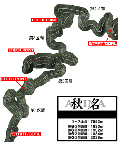
Update II: Added another variant of Mt. Akina using Eifel as a base.
Update III:
Major changes done:

- Track is now 8 meters wide
- Banking is set to Very Gentle
- Curbs are added as "gutters"
- Finish line moved to correct position.
- Deleted "Mt. Akina II"


Update IV: Finally removed that annoying big jump in Turn 2.

This track can be changed as per feedback. I tried my best to make it tight as possible.


Announcement (11/6/2015):


CLOSING THIS THREAD FOR GOOD. IT WAS FUN MAKING TRACKS FOR A FEW MONTHS. THANK YOU FOR DOWNLOADING AND ENJOYING MY CREATIONS.


I removed all the tracks from my Shared Track list.
 
Last edited:
How does altitude work on the tracks? I can see some areas which are clearly higher than others.
Are you allowed to position tracks in those mountain areas?
Thanks.
 
Sending a request now! Looks awesome! It'll just take another minute due to my PS3 crashing.

Saved, thank you very much. Would you like me to remove you as a friend to keep spots open for others?
 
Last edited:
I'm currently in a room using your track and I've gotta say it's pretty nice so far, some parts do catch you off guard abit on your first runs up and down the track.
 
You went past the Initial D layout. It's only 7,552 meters.

here's the exact layout from the Wikia website, in case you need it:

latest
 
I'm aware of that. If I have to replicate the exact measurements, chances are the roads will hit one another. So I have to make some straights longer, in order for the other hairpins to fit.

Oh I see. I'll see if I can replicate the exact layout on my end, but it will probably be over on the weekend before I get to do so, because I'd have to borrow my mom's tablet to use the Course Maker (I don't have a tablet :( )
 
How does altitude work on the tracks? I can see some areas which are clearly higher than others.
Are you allowed to position tracks in those mountain areas?
Thanks.

They are not as tall as they appear on the map.

You can put the track anywhere except on the dark grey areas.
 
Yes, we can't do chicanes, i wonder how will it works with GPS when the track has too narrow turns, because here all we can get is wipeout-like tracks...
 
- Once you're in, there's the "Save" option.
My 2km long track is saving for like 5 minutes now and i'm afraid it will never finish.

Edit: it had finished, but the game cursor was still wrongly showing busy.
 
Last edited:
Just test drive that in my AE86. Oh my god was it holy. I'll be coming back here for more. :D
 
Back