- 161

- Queretaro
- GTP_Chiroracer
I'll make our local race track and a little loop near my house that has an interesting hill with blind turns.
The problem with Long Beach is that to map it accurately, you would have to either go the wrong way down Shoreline Drive (front straight) and then the wrong way around a traffic circle (turns 2 and 3), or going the other way, go the wrong way down the street between turns 4 and 5. I also wonder if there would be access to the parking lot for the section between turns 9 and 11. Hopefully, it will be possible to map out courses in sections and merge them together.I'm going to head down to Long Beach and try to map out the course used for the Long Beach GP and next year once it is announced I will map out the Formula E race track. If I can I will also map out the oval/road course section of the Auto Club Speedway in Fontana, Ca.
Like a Polish Spa-Francorchamps
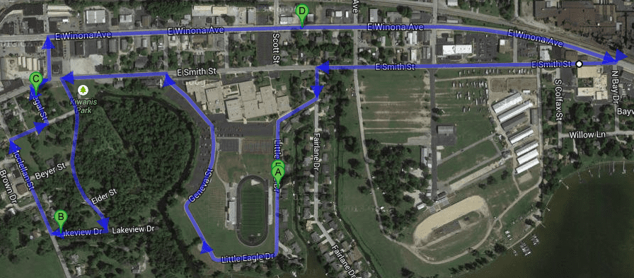
This 3-mile loop is what I call the Winonaring, about 30 minutes away from me in Warsaw. Start/Finish line located at "D". The Winona-Smith Hairpin is gonna be 🤬 nasty.
I guess it's not ready for prime time yet. If it had been in the day 1 release we might have seen something. My guess is that there are features of it that they would like to include which, for various reasons, might not make it, so they are keeping a lid on expectations.I'm still skeptical whether we're actually getting what we think we are. Why can't we see some footage of this GPS course maker??
I'd be happy with just a course maker like ModNationRacers where you can actually design the track yourself rather than it being randomly generated by set numbers.....
WHY MUST GTP SUCK ALL OPTIMISM OUT OF GT6? LET US HAVE OUR FUN FOR 🤬 SAKEI'm still skeptical whether we're actually getting what we think we are. Why can't we see some footage of this GPS course maker??
 👎
👎Someone expressing their skepticism doesn't have to affect your fun...unless you allow it to. When it comes to PD and GT, skepticism about features not yet released is quite reasonable.WHY MUST GTP SUCK ALL OPTIMISM OUT OF GT6? LET US HAVE OUR FUN FOR 🤬 SAKE
You could walk your track if it can't be driven.The problem with Long Beach is that to map it accurately, you would have to either go the wrong way down Shoreline Drive (front straight) and then the wrong way around a traffic circle (turns 2 and 3), or going the other way, go the wrong way down the street between turns 4 and 5. I also wonder if there would be access to the parking lot for the section between turns 9 and 11. Hopefully, it will be possible to map out courses in sections and merge them together.
If all else fails, the only thing to do will be to walk it, which I'll do if I have to.
")
Yes, but without so many medium- and high-speed sweepers, those are my favorite Spa features.Like a Polish Spa-Francorchamps
Would just like to point out that was my indirect way of saying "Why on earth would you just post something like 'THIS MAY NOT EVEN HAPPEN OMG' in a thread about this thing. It gets kinda annoying.Someone expressing their skepticism doesn't have to affect your fun...unless you allow it to. When it comes to PD and GT, skepticism about features not yet released is quite reasonable.
I was just looking at that. I figured that if we were able to map it we could still edit it to some extent to fix any kinks that might come from the GPS. I was probably going to walk it anyway, Inglewood to Long Beach is a looong drive in traffic but the train takes you right there.The problem with Long Beach is that to map it accurately, you would have to either go the wrong way down Shoreline Drive (front straight) and then the wrong way around a traffic circle (turns 2 and 3), or going the other way, go the wrong way down the street between turns 4 and 5. I also wonder if there would be access to the parking lot for the section between turns 9 and 11. Hopefully, it will be possible to map out courses in sections and merge them together.
If all else fails, the only thing to do will be to walk it, which I'll do if I have to.
Lot's of great ideas in this thread but does anyone know how the data from your phone is transferred to the game?.
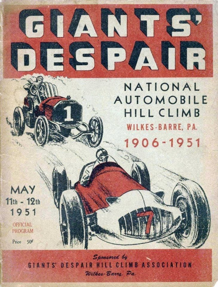
I've been there, about 2 hours north of me, well not the actual event (I was born exactly 44 years after the second date) but went around where it was held, pretty awesomeHmmm. I might like to see Giants' Despair...
Well, at least I hope people make stuff like that and aren't just driving around their suburban sprawl subdivisions.
Really only two options here I would have thought.At this point it's all theory and conjecture. Nobody really knows anything for sure yet other than that PD stated a GPS function will be forthcoming.
Lot's of great ideas in this thread but does anyone know how the data from your phone is transferred to the game? My phone has a charger cable with a usb connection, would this be the way? If it's possible I would create the route from my house, back to my house, via my friends house, about a 6 mile round trip.
The app uploads the GPS trace to your online PSN account, which the game then download off the server.
.
I don't want to wreck the hype train, but do you guys have any real experience with GPS logging? I logging my MTB rides (and uploading to strava.com) and from my experience GPS accuracy can be quite off.
I don't think that good track can be created from raw logged GPS data, it will need some editing to get shape of the corners right. Maybe draw track in Google Maps and export GPS data will be more straightforward, even though I don't know if that is possible.

