You are using an out of date browser. It may not display this or other websites correctly.
You should upgrade or use an alternative browser.
You should upgrade or use an alternative browser.
Tracks rescanning
- Thread starter Shahar
- 30 comments
- 1,992 views
- 501

- Germany
The best example is the Indianapolis road course. The awfull hairpins thankfully don't exist anymore today.
Last edited:
- 5,068

- Glasgow
- GTP_iainoflo
Gran turismo 6 have alot of tracks that look a bit old , for example Mazda laguna seca that changed in 2013 but GT6 dont have alot of those changes ( the same for the nurburgring and more). Are PD is going to re scan old tracks?
They rescanned Daytona so only fair that they do Indy as well no?
- 5,068
- Glasgow
- GTP_iainoflo
When?
Well play Daytona in GT5, then play it in GT6 - you'll see the difference.
I don't know when they did it, but it was in GT6 at launch so . . . between 2010 and 2013.
- 5,068
- Glasgow
- GTP_iainoflo
Yes , i seen the diffrent . But , its look like 1985 monza , its just the road Not the scenery or the big things (like the marking on the grass that says "DAYTONA")
Oh. Well La Sarthe 2013 was also updated . . . fully.
- 5,068
- Glasgow
- GTP_iainoflo
La Sarthe 2013 Is the proof that PD can re scanned tracks but for some reason they dont do that . Becouse of this i uplaoded this question
Yes, that's my point - they can rescan some but not others that are sorely lacking.
- 1,959

- WNC
- TRLWNC
Time, license, permission... (shrug)...
- 104

- England
- VST1G
My only concern with laser scanning is that two of the new tracks seem to struggle online. Bathurst notoriously has troubles and I've heard (haven't personally tried) Spielberg can only take so many cars. It may be coincidence, but it seems strange it's the "new" circuits causing problems. If this is true, it'll be the PS3's limits, but I can only speculate.
- 104
- England
- VST1G
PD is using a good method to scan the tracks to the game ( I'm also a 3D artist myself , And I modeled some old tracks like old Rome from GT3 in my computer in PC grafics ) . People just hear "Laser scan !!!" And think anything else is bad ( less good ). Wrong , PD method are actually in the same acuarsy level as laser scan.
Sorry for my ignorance, I was under the impression laser was the only way other than laying out smooth tracks freehand.

Please do enlighten us on methods from a designer's point of view.
")
- 104
- England
- VST1G
Thanks for the expansion Shahar & Samus. 
- 1,545

- New Zealand
- MHFanatik
FIA certification doesn't mean anything, I doubt those guys check for road surface accuracy or anything like that, most probably they just look at the general layout and major buildings around the track and call it a day.
- 1,959
- WNC
- TRLWNC
I would wager there is a large amount more than that to it.
- 1,545
- New Zealand
- MHFanatik
The new tracks are definitely laser scanned, I've just rewatched KAZ and Kazunori specifically states that they laserscanned Willow Springs, so I would imagine its also true for Silverstone and Bathurst.
- 1,545
- New Zealand
- MHFanatik
I don't know, I just have little trust in those FIA execs, they have been ruining the races they're hosting with their stupid rules and regulation for a while now, so I imagine working with PD is just an easy cash grab for them. But I might be wrong of course.I would wager there is a large amount more than that to it.
- 446

- Israel
The new tracks are definitely laser scanned, I've just rewatched KAZ and Kazunori specifically states that they laserscanned Willow Springs, so I would imagine its also true for Silverstone and Bathurst.
After reading your post I watched the part in the movie KAZ that talked about willow and they never said something about laser scanning. But maybe I missed it so can you post the time he said something about laser scanning
- 1,545
- New Zealand
- MHFanatik
At 22:15After reading your post I watched the part in the movie KAZ that talked about willow and they never said something about laser scanning. But maybe I missed it so can you post the time he said something about laser scanning
Zer0
(Banned)
- 1,624
That's looks like a digital surveyor's wheel.They use GPS data taken when 'scanning' the track on foot, like Forza/T10 do/did and also what SMS do for Project CARS with the exception of four laser scanned tracks.
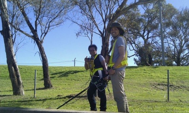
I'm pretty sure that is a GPS scanning device. It's certainly not a laser scanner.
http://en.wikipedia.org/wiki/Surveyor's_wheel
Nothing related to scan the physical layout of a track, as it measures just distances, like an hodometer. If the box is GPS related it would be just to mark coordinate points to overlap the info over the physical scanned track to scale things properly and match virtual distances. Anyway this is ONE of the many layers that PD use to record a track. Does not exist a one "all-in one" method that you can catch on a single photo, there you are missing a big part of a complex process.
- 1,545
- New Zealand
- MHFanatik
That also looks similar to how T10 measured Hockenheim for FM4.That's looks like a digital surveyor's wheel.
http://en.wikipedia.org/wiki/Surveyor's_wheel
Nothing related to scan the physical layout of a track, as it measures just distances, like an hodometer. If the box is GPS related it would be just to mark coordinate points to overlap the info over the physical scanned track to scale things properly and match virtual distances. Anyway this is ONE of the many layers that PD use to record a track. Does not exist a one "all-in one" method that you can catch on a single photo, there you are missing a big part of a complex process.
Zer0
(Banned)
- 1,624
Yep, part of. The walking GPS measurement in that video does not seems very accurate.That also looks similar to how T10 measured Hockenheim for FM4.
Similar threads
- Replies
- 2
- Views
- 957
- Replies
- 5
- Views
- 629
- Replies
- 21
- Views
- 1K
Latest Posts
-

-
 Open ◆ SNAIL [Spec] Racing - Currently Recruiting for GT7 - JOIN TODAY!!
- Latest: A_Higher_Place
-

-

-