Modified Track Path Editor + Tracks/Discussion

Ok guys, tell me where I'm wrong.
In a nut shell. I create my road (Layout) using the regular TPE. Run it, take replay and get the TED file off of it. Then, I can use the TED editor and Erans elevation tool to take that layout and synchronize the elevation to those that were obtained through the .GPX file from Geocontext.
And if I wanted to add road side objects to say, create a forest with spaced out houses and a restaurant where there is a gas station in real life, I would use Grumpy's editor?
I think I'm trying to take a crash course in the editor tools.
 
I need some help for additionnal questions on the editors (and cross check with my understanding):
  1. Is TED editor managing the 10 km limit for point to point tracks or can i bypass it ?
  2. It seems to exist some limitation on indexes (there is always a limit ;-), from the thread messages that i have read.
    To what is this limit relevant for, if it exist ?
  3. Is it possible to put the Google Map track image anywhere in the TED grid.
    The Top left corner of my image seems to be loaded always at the same place.
    Is this the top left corner of the area or can i move it by any mean (i need to be on the top side) ?
    What is the rule for locating the image or moving it (i manage the scaling) ?
  4. Is there a strict limitation on the number of points that i can load within the elevation editor ?
    (i can down sample for GT6 but i would like to enter all 2500 points first and adjust with the tools)
  5. Following Mr Grumpy answer to my last circuit creation, does it exist other objects or road type than the ones in the tempate that allow to create run-off areas bigger than this 1 meter sand band along the rail ?
Thank you for your help.
 
@VelociRaptor partial reply
1. You can make the stage very long indeed, it's the game that won't work if you go too far.
4. I don't know but 2500 points doesn't seem like an extreme amount, though it may impose some limitations maybe.
5. Probably not.

However, at least in Andalusia bigger run-off areas will form, but the example I'm thinking was begun in TPE and I can't guess what it was exactly.
 
I need some help for additionnal questions on the editors (and cross check with my understanding):
  1. Is TED editor managing the 10 km limit for point to point tracks or can i bypass it ?
  2. It seems to exist some limitation on indexes (there is always a limit ;-), from the thread messages that i have read.
    To what is this limit relevant for, if it exist ?
  3. Is it possible to put the Google Map track image anywhere in the TED grid.
    The Top left corner of my image seems to be loaded always at the same place.
    Is this the top left corner of the area or can i move it by any mean (i need to be on the top side) ?
    What is the rule for locating the image or moving it (i manage the scaling) ?
  4. Is there a strict limitation on the number of points that i can load within the elevation editor ?
    (i can down sample for GT6 but i would like to enter all 2500 points first and adjust with the tools)
  5. Following Mr Grumpy answer to my last circuit creation, does it exist other objects or road type than the ones in the tempate that allow to create run-off areas bigger than this 1 meter sand band along the rail ?
Thank you for your help.
Some investigations i have done with TED :
  1. Yes. I was able to design and upload a track longer than 10 km.
  2. Looking at the generated file, 100 road segments seems to be the max.
    Start and Finish lignes using 7 segments (3 start / 4 Finish)
    It still works.
  3. ???? help ??? the image is in the middle of the scenery.
  4. I can download the terrain profile with 2500 points then apply Track elevation points on it.
    There is a PS3 limitation when uploading that may hang the system (probably memory)
    Resampling did not helped to manage number of points.
    Points become regularly spaced (high count) whereas some sections are constant slope while other require more resolution.
    I stayed original points and moved them manually to adjust locations with slopes breaks.
  5. The only option is to change the scenery to benefit from bigger sandboxes in Andalousia.
 
I can download the terrain profile with 2500 points then apply Track elevation points on it.
There is a PS3 limitation when uploading that may hang the system (probably memory)
Resampling did not helped to manage number of points.
Points become regularly spaced (high count) whereas some sections are constant slope while other require more resolution.
I stayed original points and moved them manually to adjust locations with slopes breaks.

The resolution of the elevation profile is independent of the resolution of the track. Track heights are generated by sampling the elevation profile. If you have 1000 height data items when you load the file, then apply an elevation profile with 2000 data points, then the output file will still have 1000 height data items.
 
The resolution of the elevation profile is independent of the resolution of the track. Track heights are generated by sampling the elevation profile. If you have 1000 height data items when you load the file, then apply an elevation profile with 2000 data points, then the output file will still have 1000 height data items.
I have seen that. But I tried to use resample.
I think that my concerns are coming from TED editor. If I slightly adjust the track, the elevation seems to be corrupted so as it hangs the PS3 and the elevation editor raise an error inside python (Not sûre at this point but investigating inside 010 editor).
As well, if I use the CTRL-Z inside TED during creation, the screen is correct but the saved track structure reflects sometimes a previous version. Not sure 100% to reproduce it but now I save, reload, check each time I use CTRL-Z. It helps.
 
Unless you scale the pit segment length then it's about 450 meters. That leaves the pit wall straight. You can also try omitting the second pit segment, (use 1, 3, 4, 5, 6) as it doesn't really contain anything graphically important, that way you could theoretically get it down to 350 meters. Not sure if the pit will work properly if you do that, but you can always try.

Keep in mind that as the pit segments are 100 meters long they have a fairly low mesh resolution, so curves and banks that you place on a pit road segment will not be as smooth as they are on the rest of the track.

Hey guys,

I don't know if it has been stated already but I wasn't able to find my needed information.

At the Andalusia theme the homestraight consists of 3 pit segments (1 = 200 m, 2 = 300 m, 3 = 200 m). Has anyone tried the minimum working homestraight length? I do estimate that the segment #2 is both graphically and functionally very important, but what about segments #1 and #3?

I'm not really sure but when racing at Andalusia the pits always seemed quite short. This makes me think that segment #3 could be bend easily without causing any problems. Am I right on this?

The Andalusia pit can be bent quite a bit. There is sometimes a pit navigation issue but I'm not sure what triggers it.

Regarding the Track Layout Creator, I'm working on a toolbar, as it's a bit more user-friendly than hiding all the commands behind keybinds. I made a couple of icons, they look like this:

0_selectbutton.png 1_translatebutton.png 2_rotatebutton.png 3_scalebutton.png 4_mirrorvbutton.png 5_mirrorybutton.png 6_reversebutton.png 7_zoominbutton.png 8_zoomoutbutton.png

And the toolbar itself will probably look something like this:

Skärmbild (57).png
 
I have seen that. But I tried to use resample.
I think that my concerns are coming from TED editor. If I slightly adjust the track, the elevation seems to be corrupted so as it hangs the PS3 and the elevation editor raise an error inside python (Not sûre at this point but investigating inside 010 editor).
As well, if I use the CTRL-Z inside TED during creation, the screen is correct but the saved track structure reflects sometimes a previous version. Not sure 100% to reproduce it but now I save, reload, check each time I use CTRL-Z. It helps.
I am facing several problems because my track has been corrupted at one moment with the editor and i try to recover it.
The elevation profile has been completely messed, hanging the loading in PS3.
I have flattened the full track manually to -154. (some points where at -154, some on the terrain and others at the correct altitude).
Now the track loads again in the PS3. But i the information on track length, turns and straight is empty and it does not launch the car on the track (locked on spinning symbol).
PS3 Track Screen.png

It opens also in TED Editor, but i can't open the elevation Editor (banking editor works as well as points edition).
When launching the elevation editor, i get the following error message:
Code:
Exception in Tkinter callback
Traceback (most recent call last):
  File "/Library/Frameworks/Python.framework/Versions/3.6/lib/python3.6/tkinter/__init__.py", line 1699, in __call__
    return self.func(*args)
  File "/Users/xxxxxx/PS3/GT6/ted-editor-ted-editor-0.2/ted-editor.py", line 2574, in onElevationEdit
    trackobj = eed_rf2.initFromTedFile(self.tedfile)
  File "eledit/readfile_2.py", line 370, in initFromTedFile
    Track = TrackObject(tedfile, filename)
  File "eledit/readfile_2.py", line 25, in __init__
    self.measure_track()
  File "eledit/readfile_2.py", line 34, in measure_track
    self.measure_track_length()
  File "eledit/readfile_2.py", line 281, in measure_track_length
    angle = math.asin(opp/hyp)*2
ValueError: math domain error
This track is 20 km long (and i have previous versions that work, and it was working before the editor messed the file)
@eran004 can you provide me with some guidance for searching the root cause please ?
 
I am facing several problems because my track has been corrupted at one moment with the editor and i try to recover it.
The elevation profile has been completely messed, hanging the loading in PS3.
I have flattened the full track manually to -154. (some points where at -154, some on the terrain and others at the correct altitude).
Now the track loads again in the PS3. But i the information on track length, turns and straight is empty and it does not launch the car on the track (locked on spinning symbol).
View attachment 635527

It opens also in TED Editor, but i can't open the elevation Editor (banking editor works as well as points edition).
When launching the elevation editor, i get the following error message:
Code:
Exception in Tkinter callback
Traceback (most recent call last):
  File "/Library/Frameworks/Python.framework/Versions/3.6/lib/python3.6/tkinter/__init__.py", line 1699, in __call__
    return self.func(*args)
  File "/Users/xxxxxx/PS3/GT6/ted-editor-ted-editor-0.2/ted-editor.py", line 2574, in onElevationEdit
    trackobj = eed_rf2.initFromTedFile(self.tedfile)
  File "eledit/readfile_2.py", line 370, in initFromTedFile
    Track = TrackObject(tedfile, filename)
  File "eledit/readfile_2.py", line 25, in __init__
    self.measure_track()
  File "eledit/readfile_2.py", line 34, in measure_track
    self.measure_track_length()
  File "eledit/readfile_2.py", line 281, in measure_track_length
    angle = math.asin(opp/hyp)*2
ValueError: math domain error
This track is 20 km long (and i have previous versions that work, and it was working before the editor messed the file)
@eran004 can you provide me with some guidance for searching the root cause please ?

Check that the bank and road data are in the correct order and that there is no overlap in their distance values.
 
Check that the bank and road data are in the correct order and that there is no overlap in their distance values.
Thank you. I will check that.
I am making progress. The track works again in GT6, still not possible to edit elevation.

As i am only able to load the image in the middle of Eifel scenery (0,0), the track goes up to the bottom border.
I seems that TED Editor is not able to handle correctly the elevation saving at some distance of the border.
Once the track has been flatened, i have loaded and saved it several times.
Each time, the elevation of the last (around) 200 last points was replaced by other values even if i did not touched anything between loading and saving.
So, once the part of the track layout i am working on is adjusted, i save, flatten, reload, upload.
 
Check that the bank and road data are in the correct order and that there is no overlap in their distance values.
Thank you again.
I have checked all the bank data and corrected some crossed points.
Now i can save the track with TED Editor without elevation corruption (stays flat).
Anyway, still unable to launch elevation editor but the error has changed.
Code:
Exception in Tkinter callback
Traceback (most recent call last):
  File "/Library/Frameworks/Python.framework/Versions/3.6/lib/python3.6/tkinter/__init__.py", line 1699, in __call__
    return self.func(*args)
  File "/Users/xxxxx/PS3/GT6/ted-editor-ted-editor-0.2/ted-editor.py", line 2582, in onElevationEdit
    self.onElevationClose()
  File "/Users/xxxxxx/PS3/GT6/ted-editor-ted-editor-0.2/ted-editor.py", line 2585, in onElevationClose
    self.eleveditor.structure.mod = [token[1]+self.eleveditor._first_z for token in tokenlist]
AttributeError: 'ElevationEditor' object has no attribute 'structure'
It's like i was missing elevation points now ?
Going to check road data.
 
Well, at this point, i have checked all the binary and it seems OK in terms of structure and points ordering.
So, what i think, is that the number of elevation points is corrupted in front of what it should be.
Then preventing the elevation editor of launching properly and may be corrupting TED editor behaviour.

My last hopefull question is : Is there a way to get or compute the expected number of elevation points ?
So as to correct the elevation array size.
 
Thank you again.
I have checked all the bank data and corrected some crossed points.
Now i can save the track with TED Editor without elevation corruption (stays flat).
Anyway, still unable to launch elevation editor but the error has changed.
Code:
Exception in Tkinter callback
Traceback (most recent call last):
  File "/Library/Frameworks/Python.framework/Versions/3.6/lib/python3.6/tkinter/__init__.py", line 1699, in __call__
    return self.func(*args)
  File "/Users/xxxxx/PS3/GT6/ted-editor-ted-editor-0.2/ted-editor.py", line 2582, in onElevationEdit
    self.onElevationClose()
  File "/Users/xxxxxx/PS3/GT6/ted-editor-ted-editor-0.2/ted-editor.py", line 2585, in onElevationClose
    self.eleveditor.structure.mod = [token[1]+self.eleveditor._first_z for token in tokenlist]
AttributeError: 'ElevationEditor' object has no attribute 'structure'
It's like i was missing elevation points now ?
Going to check road data.

Looks like the loading fails for some reason. Can you send me the file you are working on?

Edit: The number of height data items is the sum of the divNum in the bank data +1.
 
Looks like the loading fails for some reason. Can you send me the file you are working on?

Edit: The number of height data items is the sum of the divNum in the bank data +1.
Thank you. So my height point number is messed and i think that is the root cause of everything.
I have thought when waking up that, as the track now loads again in GT6, i should record a run, then extract .ted file.
It should restore everything ok and i should have thought about that way before.
I will you know if the height points number is back.
 
Looks like the loading fails for some reason. Can you send me the file you are working on?

Edit: The number of height data items is the sum of the divNum in the bank data +1.
The .ted extracted is the same as the one i have inserted.
The PS3 gives you back what you put inside.
So, going back to the binary.
I have 210 CP entry count, 209 bank entry count and 3968 height entry count.
I will try to lower this count to 210 and if it does not work send you the file.
 
The Andalusia pit can be bent quite a bit. There is sometimes a pit navigation issue but I'm not sure what triggers it.
Andalusia_Terrain_Potrero de los Funes.png

This is supposed to be the homestraight section of the track I'm aiming to create at the moment. The driving direction is to the right. So i have 315 m of straight available, followed by a 330 m long R 684. I hope the pits will work with such a rather big radius. If I use both those segments completely for the the homestraight I got culmulated 645 m already which means I'd have to use at least 55 m length of the 74 m long R 122. Is this supposed to work properly at Andalusia? :eek: :confused:

Regarding the Track Layout Creator, I'm working on a toolbar, as it's a bit more user-friendly than hiding all the commands behind keybinds. I made a couple of icons, they look like this:


And the toolbar itself will probably look something like this:


You always keep improving - great work mate! 👍 Is there a function available to rotate the track?

-----------------------------------------------------------------------------------------------------------------

Finally some general questions:

I'm in the process of creating a new track at the Andalusia theme. The original track goes around a lake. So it's very tempting to try building it around the lake at Andalusia. A problem here might be that most of the track needs to be drawn out of bounds area. I've done that once in the past which resulted in trees on the road, flying houses in the air etc.. Is there a way to avoid such appearances?

Furthermore I've noticed during my first test that the water surface isn't exactly bordered by the blue line (-200 m in the Track Layout Creator). Will it be possible to decorate the track when the road runs at the border of the water area? And what happens if I adjust the heights afterwards?

I guess the best way to avoid any track loading problems is to go step by step. I'll start with drawing the track using @eran0004's Track Layout Creator. Then I'll use the elevation editor to adjust the heights. Last step would be to manually add curbs and decorations via hex editing. Or should I progress in a different order?

Regarding the hex editor:
The pos values are out of true. Would it be possible to manually adjust them to integers?
 
I came back to 210 but it seems that there is another internal variable the adjusts the count as i have a new error :
Code:
Exception in Tkinter callback
Traceback (most recent call last):
  File "/Library/Frameworks/Python.framework/Versions/3.6/lib/python3.6/tkinter/__init__.py", line 1699, in __call__
    return self.func(*args)
  File "/Users/xxxxxx/PS3/GT6/ted-editor-ted-editor-0.2/ted-editor.py", line 2027, in loadAndImportTed
    self.importTed(tedfile)
  File "/Users/xxxxxx/PS3/GT6/ted-editor-ted-editor-0.2/ted-editor.py", line 2106, in importTed
    hs2 = get_segment_heights(self.heights, self.banks[i-1])
  File "/Users/xxxxxx/PS3/GT6/ted-editor-ted-editor-0.2/ted-editor.py", line 2052, in get_segment_heights
    bank.total_divisions+bank.divisions)]
  File "/Users/xxxxxx/PS3/GT6/ted-editor-ted-editor-0.2/ted-editor.py", line 2051, in <listcomp>
    sh = [heights[j].height for j in range(bank.total_divisions,
IndexError: list index out of range
I think that is because at one point in the creation i have used the "Resample" command inside the elevation editor.
So there should be an adjustment to the default size to compute. I don't remember exactly, i sampled either 100m either 200m over 20km because i did different tests or sampling / smoothing.
 
View attachment 635584
This is supposed to be the homestraight section of the track I'm aiming to create at the moment. The driving direction is to the right. So i have 315 m of straight available, followed by a 330 m long R 684. I hope the pits will work with such a rather big radius. If I use both those segments completely for the the homestraight I got culmulated 645 m already which means I'd have to use at least 55 m length of the 74 m long R 122. Is this supposed to work properly at Andalusia? :eek: :confused:

The only way to find out is to try it.
You can always start the main straight at the straight bit and let the extra 55 meters be used for whatever comes after the R684 turn.

Is there a function available to rotate the track?

Select the points you want to rotate (press <a> to select all points) and then press <r> to enter rotation mode. Click and drag to rotate.

I'm in the process of creating a new track at the Andalusia theme. The original track goes around a lake. So it's very tempting to try building it around the lake at Andalusia. A problem here might be that most of the track needs to be drawn out of bounds area. I've done that once in the past which resulted in trees on the road, flying houses in the air etc.. Is there a way to avoid such appearances?

The only way is to figure out where the trees are and avoid drawing the track over them.

Furthermore I've noticed during my first test that the water surface isn't exactly bordered by the blue line (-200 m in the Track Layout Creator). Will it be possible to decorate the track when the road runs at the border of the water area? And what happens if I adjust the heights afterwards?

Decorations are placed on the track border and not on the terrain, so it doesn't matter if your track runs across water or is high up in the air, you can always add decorations.

If you adjust the heights to go below the terrain, the terrain is deformed. Not sure how the water reacts to that.
If you adjust the heights to go above the terrain, nothing special happens.

I guess the best way to avoid any track loading problems is to go step by step. I'll start with drawing the track using @eran0004's Track Layout Creator. Then I'll use the elevation editor to adjust the heights. Last step would be to manually add curbs and decorations via hex editing. Or should I progress in a different order?

Sounds like a good order. Keep in mind that the distance values in the Track Layout Creator are the flat distances, so you might need to compensate for that when you add the decorations and the curbs. Start by adding the decorations at their flat distance, then test the track and see if you need to make any adjustments.

Finally, a general note about the Elevation Editor: Avoid 180+ degree turns that are a single CP point. The elevation editor can't calculate the angle of the corner if it's greater than 180 degrees. Keep in mind that 180 degree turns can suffer from rounding errors and get an angle slightly above 180 degrees, so it's safest to stay below 180. If you have any 180+ degree turns that are single cp point you need to split them and make them two 90+ degree turns.

Here is an example from @VelociRaptor 's track:


splithere.png

(This is not a problem for tracks made with the Track Layout Creator, as the polygon method of drawing the track means that no turn can be greater than 90 degrees.)
 
Looks like there is a limit to the number of checkpoints you can have. I made a rather long track at Andalusia and ended up with 19 checkpoints. The track loaded fine, but after completing the first lap when testing the track the position indicator went from 1/1 to 1/3, then to 1 / 3 (with spaces, very odd), then 1/8, then 1/33, etc. When exiting the test drive the PS3 froze with a black screen.

At first I thought that perhaps I had too many road segments (about 160) so I reduced them down to 90 and tried again, with the same result. Next I tried reducing the number of checkpoints from 19 to 9 and that made the track work properly.

Not sure what the checkpoint limit is though, perhaps sixteen?
 
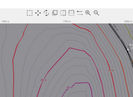
One of the toughest programming challenges yet: connecting a bunch of unconnected and unordered line segments into a polyline.

This is for drawing the contour map. Drawing a single polyline is faster than drawing hundreds of small line segments, and it also allows the use of the smooth option, to get nicely curved contours.

Here is the sort and connect algorithm I arrived at in the end. The line segments are stored in a dictionary lineDict, where each elevation level is a key.

It takes the first line segment in the list and checks if the start or the end coordinates matches the start or end coordinates of any of the other line segments. If there is a match it adds the line segment to the matching line. If there is no match, the segment is appended to the end of the list.

Code:
    # 5. Sort and connect the lines
    for elevation in lineDict:
        coordinates = lineDict[elevation]
        lines = [[a, b] for a, b in coordinates]
        for i in range(len(lines)):
            line = lines.pop(0)
            start = line[0]
            end = line[-1]
            for other_line in lines:
                other_start = other_line[0]
                other_end = other_line[-1]
                if (start.x, start.y) == (other_start.x, other_start.y):
                    other_line.reverse()
                    other_line += line[1:]
                    break
                elif (start.x, start.y) == (other_end.x, other_end.y):
                    other_line += line[1:]
                    break
                elif (end.x, end.y) == (other_start.x, other_start.y):
                    other_line.reverse()
                    line.reverse()
                    other_line += line[1:]
                    break
                elif (end.x, end.y) == (other_end.x, other_end.y):
                    line.reverse()
                    other_line += line[1:]
                    break
            else:
                lines.append(line)

        lineDict[elevation] = lines
 
I have a few questions regarding the Andalusia Track Codes composed by @Mr Grumpy. There are way more possibilities of decoration than in the TPE app. So before manually hex editing the whole scenery stuff I'd like to clear what code generates what.

Parking Road..................... 13027506505615099153 = 100m

Parking Road.png


--> Is that the classic "Restaurant" which randomly get's generated by the TPE app usually?

Medic Road....................... 10656079826827822353 = 100m

Medic Road.png


--> I'm pretty sure this is supposed to be that because of those 2 ambulances next to the track.

Building Road Type 1............. 10954364719393644117 = 100m

Building Road Type 1.png


--> Is that a Building Road or a normal Building?

Building Road Type 2............. 11670155585168842325 = 100m

Building Road Type 2.png


--> Same question as above: Building Road or a normal Building?

Forest Road Start............. 1. 12262457518915536145 = 50m

Forest Road.png


--> This is pretty clear.

I guess that every Forest Road needs a Start and Finish Segment and in between there are several options as follows:

Trees.................. 2. 12609516165199774993 = 100m
Mix & Building Type 1........ 2. 9431585095388995157 = 100m
Match Building Type 2........ 2. 9691949448846351957 = 100m

Building Raised........ 2. 10719130221611009297 = 100m

Building Raised.png


--> I'm guessing this could be effect of that code!?

Decreased Radius Road......... 1. 9433898354799217496 = 50m
3 Parts 2. 10429475347424807768 = 100m
3. 12293684118179482456 = 50m

--> I haven't found an example for that code yet? What does it induce? Maybe a narrow road with concrete walls?

All above road structures use "int flag 0" or "int flag 1".
"int flag 0" = structures appear on X side of track.
"int flag 1" = structures appear on Y side of track.

--> What is left side and what is right side of track?

Single Tent...................... 9855204935338532437 = 40m
TRACK_LEFT_A (0) or TRACK_RIGHT_A (3)
RAILTYPE_NORMAL (0) RAILTYPE_START (1)

Double Tent...................... 13668346444837789269 = 40m
TRACK_LEFT_AB (2) or TRACK_RIGHT_AB (5)
RAILTYPE_START (1) RAILTYPE_NORMAL (0)

Tent.png


--> I guess these are the 2 types available with Single Tent in front and Double Tent behind!?

Building Type 1.................. 13268933452885368405 = 40m
TRACK_LEFT_AB (2) or TRACK_RIGHT_AB (5)
RAILTYPE_START (1) RAILTYPE_NORMAL (0)

Building Type 2.................. 11127471830070697557 = 40m
TRACK_LEFT_AB (2) or TRACK_RIGHT_AB (5)
RAILTYPE_START (1) RAILTYPE_NORMAL (0)

Building Type 3.................. 12147537145670114901 = 40m
TRACK_LEFT_AB (2) or TRACK_RIGHT_AB (5)
RAILTYPE_START (1) RAILTYPE_NORMAL (0)

--> In the TPE app there is only 1 building icon and you can place a building on the inner decoration line or on both decoration lines (which makes 2 different types of buildings). So what's the difference between those 3 types of buildings?

Rock Bank Type 1.............. 1. 9383531457118946577 = 50m
3 Parts 2. 11495438207378998545 = 100m
TRACK_LEFT_AB (2) 3. 9793640498186372369 = 50m
RAILTYPE_START (1)

Rock Bank 1.png


--> Is this supposed to be the Rock Bank? Is Type 1 the grey coloured one?

Rock Bank Type 2.............. 1. 11486993958077678865 = 50m
3Parts 2. 10205719864090772753 = 100m
TRACK_LEFT_AB (2) 3. 11222970429923083537 = 50m
RAILTYPE_START (1)

Rock Bank 2.png


--> This could be the other type of Rock Bank. Is Type 2 the brown coloured one?

When using the objects with 3 parts (Forest Road, Decreased Radius Road, Rock Bank Type 1 and 2) is it necessary to always use the parts 1,2 and 3 or is it possible to omit a part?
 
Sorry for double posting but I've got problems with getting @tarnheld's TED Editor running.

I added some changes to make it work with Python 3.4.4 (downloadable here), please download the ted-editor again. And i found a windows installer of the python 3.4 version of pillow here, download and double click to install (numpy should be installed already).
Hope this helps!

I've followed all the instructions given above - downloaded Python 3.4.4, installed the pillow and downloaded plus extracted the ted-editor zip file.

Then I've run the pipinstall.bat first and then tried to start the TedEditor.bat where I got an error message. I followed the instructions in the message (created pythonenv.bat and inserted the line PATH=^<C:\Python34^>;^<C:\Python34^>\Scripts;) but after retrying it's still not working. :banghead:

Python.png


Any ideas what's the problem? Or have I done something wrong?
 
Sorry for double posting but I've got problems with getting @tarnheld's TED Editor running.


I've followed all the instructions given above - downloaded Python 3.4.4, installed the pillow and downloaded plus extracted the ted-editor zip file.

Then I've run the pipinstall.bat first and then tried to start the TedEditor.bat where I got an error message. I followed the instructions in the message (created pythonenv.bat and inserted the line PATH=^<C:\Python34^>;^<C:\Python34^>\Scripts;) but after retrying it's still not working. :banghead:

View attachment 635812

Any ideas what's the problem? Or have I done something wrong?

Sorry for the late reply, you should remove the "^<>" characters, i.e. the pythonenv.bat should look like this:

Code:
set PATH=C:\Python34;%PATH%

Hope this helps, if there are still errors, please post a screenshot of the output in the cmd window. 👍
 
I have a few questions regarding the Andalusia Track Codes composed by @Mr Grumpy. There are way more possibilities of decoration than in the TPE app. So before manually hex editing the whole scenery stuff I'd like to clear what code generates what.

Parking Road..................... 13027506505615099153 = 100m

View attachment 635796

--> Is that the classic "Restaurant" which randomly get's generated by the TPE app usually?

Medic Road....................... 10656079826827822353 = 100m

View attachment 635795

--> I'm pretty sure this is supposed to be that because of those 2 ambulances next to the track.

Building Road Type 1............. 10954364719393644117 = 100m

View attachment 635792

--> Is that a Building Road or a normal Building?

Building Road Type 2............. 11670155585168842325 = 100m

View attachment 635793

--> Same question as above: Building Road or a normal Building?

Forest Road Start............. 1. 12262457518915536145 = 50m

View attachment 635794

--> This is pretty clear.

I guess that every Forest Road needs a Start and Finish Segment and in between there are several options as follows:

Trees.................. 2. 12609516165199774993 = 100m
Mix & Building Type 1........ 2. 9431585095388995157 = 100m
Match Building Type 2........ 2. 9691949448846351957 = 100m

Building Raised........ 2. 10719130221611009297 = 100m

View attachment 635791

--> I'm guessing this could be effect of that code!?

Decreased Radius Road......... 1. 9433898354799217496 = 50m
3 Parts 2. 10429475347424807768 = 100m
3. 12293684118179482456 = 50m

--> I haven't found an example for that code yet? What does it induce? Maybe a narrow road with concrete walls?

All above road structures use "int flag 0" or "int flag 1".
"int flag 0" = structures appear on X side of track.
"int flag 1" = structures appear on Y side of track.

--> What is left side and what is right side of track?

Single Tent...................... 9855204935338532437 = 40m
TRACK_LEFT_A (0) or TRACK_RIGHT_A (3)
RAILTYPE_NORMAL (0) RAILTYPE_START (1)

Double Tent...................... 13668346444837789269 = 40m
TRACK_LEFT_AB (2) or TRACK_RIGHT_AB (5)
RAILTYPE_START (1) RAILTYPE_NORMAL (0)

View attachment 635799

--> I guess these are the 2 types available with Single Tent in front and Double Tent behind!?

Building Type 1.................. 13268933452885368405 = 40m
TRACK_LEFT_AB (2) or TRACK_RIGHT_AB (5)
RAILTYPE_START (1) RAILTYPE_NORMAL (0)

Building Type 2.................. 11127471830070697557 = 40m
TRACK_LEFT_AB (2) or TRACK_RIGHT_AB (5)
RAILTYPE_START (1) RAILTYPE_NORMAL (0)

Building Type 3.................. 12147537145670114901 = 40m
TRACK_LEFT_AB (2) or TRACK_RIGHT_AB (5)
RAILTYPE_START (1) RAILTYPE_NORMAL (0)

--> In the TPE app there is only 1 building icon and you can place a building on the inner decoration line or on both decoration lines (which makes 2 different types of buildings). So what's the difference between those 3 types of buildings?

Rock Bank Type 1.............. 1. 9383531457118946577 = 50m
3 Parts 2. 11495438207378998545 = 100m
TRACK_LEFT_AB (2) 3. 9793640498186372369 = 50m
RAILTYPE_START (1)

View attachment 635798

--> Is this supposed to be the Rock Bank? Is Type 1 the grey coloured one?

Rock Bank Type 2.............. 1. 11486993958077678865 = 50m
3Parts 2. 10205719864090772753 = 100m
TRACK_LEFT_AB (2) 3. 11222970429923083537 = 50m
RAILTYPE_START (1)

View attachment 635797

--> This could be the other type of Rock Bank. Is Type 2 the brown coloured one?

When using the objects with 3 parts (Forest Road, Decreased Radius Road, Rock Bank Type 1 and 2) is it necessary to always use the parts 1,2 and 3 or is it possible to omit a part?
All of them are correct. Regarding the int flag, the reason I put side y & x is because some props appear on different sides regardless of being int flag 1 or 0.

If you want trees on the left or right & it ends up being on the wrong side just change the int flag
 
Track Layout Creator 1.5.1b

Changes:
  • Contour map lines are now rounded
  • Contour map values changed to absolute values (0 m = 0.0 in the heightmap file)
  • Graphics made more efficient (and faster)
  • Toolbar added above the canvas
  • New tools:
    • Pan (hand icon): click and drag to pan the view (note: the contour map is currently not updated when panning with the pan tool)
    • Selection (arrow icon): click on polygon points to select. Shift-click to add to/remove from selection.
    • Pen (pen icon): click to add a point. Click on a line to insert a point. Shift-click to delete a point.
    • All tools: Right-click on a point and drag to change corner radius.
    • All tools: Right-click elsewhere and drag to pan the view (panning in this way updates the contour map)
  • Control for road length factor added. Used to increase/decrease the length of all road segments (excluding start). Example: 100 m road * 1.2 road length factor = 120 m road; 50 m road * 1.2 road length factor = 60 m road.
  • Checkpoints cap set to 9, to avoid timing error and game crash.
 

Attachments

  • Track Layout Creator 1.5.1b.zip
    3.7 MB · Views: 26

Latest Posts

Back